Description
InSAR Imaging of Aleutian Volcanoes, Softcover reprint of the original 1st ed. 2014
Monitoring a Volcanic Arc from Space
Geophysical Sciences Series
Authors: Lu Zhong, Dzurisin Daniel
Language: English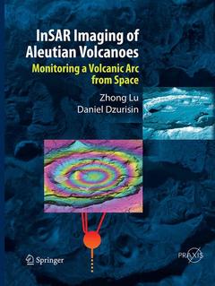
Subject for InSAR Imaging of Aleutian Volcanoes:
Approximative price 210.99 €
In Print (Delivery period: 15 days).
Add to cart the print on demand of Lu Zhong, Dzurisin Daniel
Publication date: 09-2016
Support: Print on demand
Approximative price 210.99 €
In Print (Delivery period: 15 days).
Add to cart the book of Lu Zhong, Dzurisin Daniel
Publication date: 04-2014
390 p. · 21x27.9 cm · Hardback
Description
/li>Contents
/li>Biography
/li>Comment
/li>
Interferometric synthetic aperture radar (InSAR) is a relatively new remote sensing tool that is capable of measuring ground-surface deformation with centimeter-to-subcentimeter precision at a spatial resolution of tens of meters over an area of hundreds to thousands of square kilometers. With its global coverage and all-weather imaging capability, InSAR has become an increasingly important technique for studying volcanoes in remote regions such as the Aleutian Islands. The spatial distribution of surface deformation data derived from InSAR images enables the construction of detailed mechanical models to enhance the study of magmatic processes.
InSAR Imaging of Aleutian Volcanoes:
? Provides a theoretical framework for InSAR observations and capabilities
? Discusses state-of-the-art InSAR analysis techniques
? Describes the structure, eruptive history, and magma composition of volcanoes along the entire Aleutian arc
? Presents conceptual models for the magma plumbing systems of Aleutian volcanoes based on InSAR results combined with geophysical, geological and geochemical observations.
? Synthesizes observations of deformation along the Aleutian arc and compares those results to other active arcs around the world.
? Is illustrated throughout with high-resolution color satellite radar images
Foreword,- Preface,- Chapter 1. Introduction to interferometric synthetic aperture radar,- Chapter 2. Practical issues in InSAR analysis,- Chapter 3. Recent advances in InSAR image processing and analysis, -Chapter 4. Tectonic setting of Aleutian volcanism,- Chapter 5. Role of ground surface deformation in volcano monitoring,- Chapter 6. InSAR imaging of Aleutian volcanoes, -Chapter 7. InSAR observations and insights into Aleutian volcanism, Glossary, Index.
Details, for the first time, different styles of volcanism along a single volcanic arc
Illustrated in colour throughout with unpublished high-resolution, high-quality satellite radar images
Supplies satellite InSAR deformation images of a wide spectrum of more than 40 active Aleutian volcanoes
Describes eruptive style, size, volume, and magma composition of volcanoes along the entire Aleutian arc
Explains arc volcanism derived from InSAR deformation mapping and modeling
Emphasizes the importance of InSAR for volcano studies and eruption forecasting
Metadata enables readers to explore different modelling techniques and conduct geomorphic studies